
HAZEL Bruce, who lives at Overcombe near Weymouth, sent in this quartet of fascinating photographs from the past.
Today Overcombe, which lies between Weymouth and Preston, is a highly developed residential area but as these images show, it wasn’t always like this.
Hazel, who is a Weymouth and Portland borough councillor, has lived in Overcombe for years and was prompted to send in the pictures by Godfrey Barnes’s map of plans for Overcombe, dating back to 1926, which featured in Looking Back on March 29.
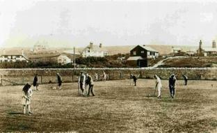
The first of the four pictures shows the Overcombe Putting Green which was then overlooked by just a few houses. Several of the homes are still in situ, the exception being the dark home, end-on to the green, which has since been demolished and replaced.
Judging by the fashions of the day, the pictures date back to the 1920s.
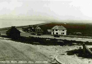
The second image shows the road stretching from Overcombe towards Weymouth and was taken from up Bowleaze Coveway.
You can see the Overcombe café, which has been replaced by a block of flats today – and the white building that is still standing and is now Joys shop and post office.
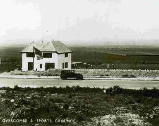
Picture number three again shows the building that is now Joys as well as a clearer idea of the position of the putting green.
As with so much along the Preston Road, this has long since been built on and has sadly been buried beneath several blocks of flats.
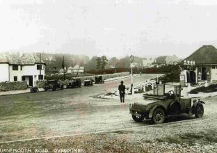
The final picture is taken at the junction of Bowleaze Coveway and Preston Road, which was then called Bournemouth Road. You can see the houses stretching away to the east and a garage in the foreground.
This remained, in more modern incarnation, for several decades but has now been bulldozed to make way for more houses.


Comments: Our rules
We want our comments to be a lively and valuable part of our community - a place where readers can debate and engage with the most important local issues. The ability to comment on our stories is a privilege, not a right, however, and that privilege may be withdrawn if it is abused or misused.
Please report any comments that break our rules.
Read the rules here